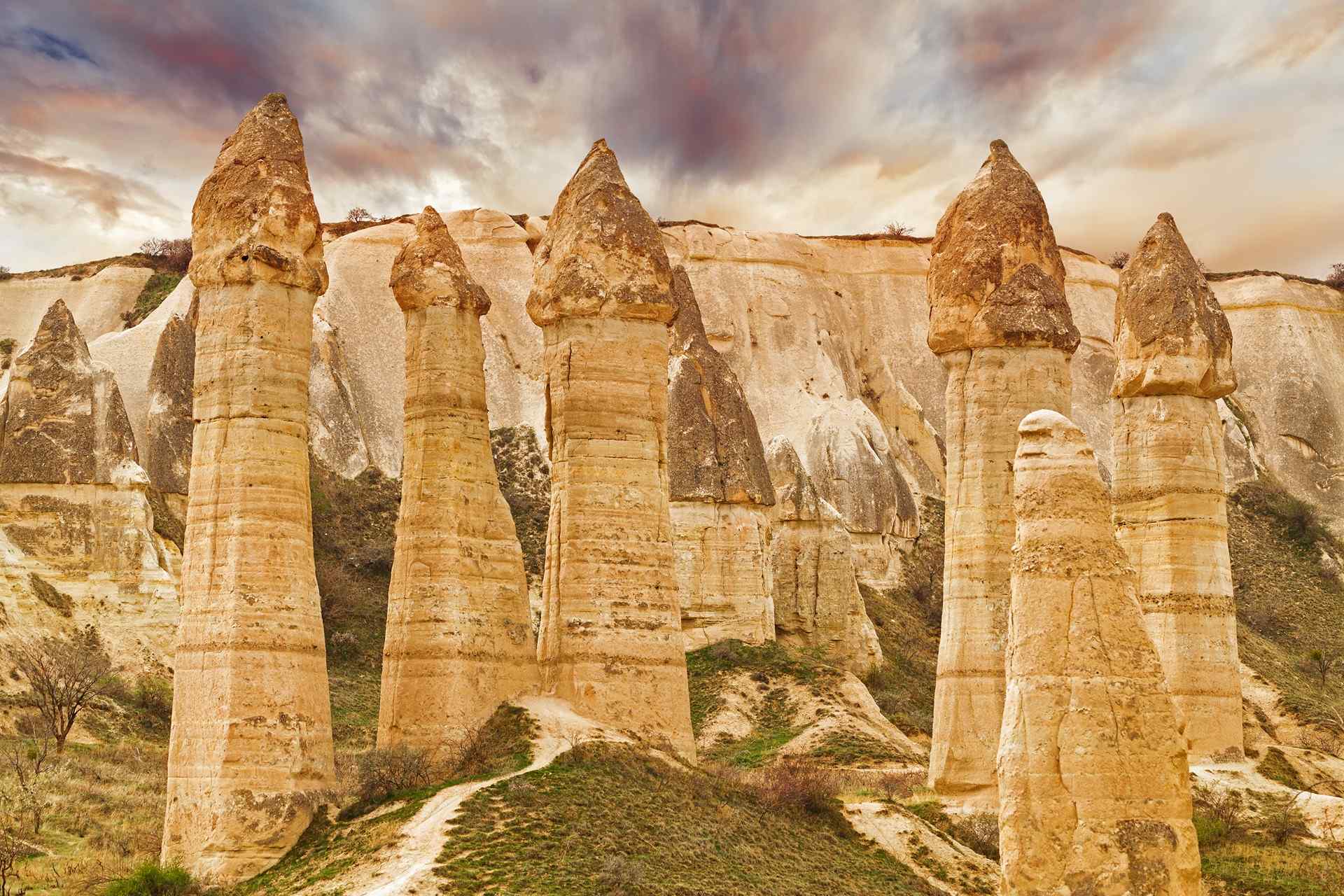
Of all Cappadocia's sculpted valleys, Mushroom Valley earns its name the moment you step off the path. Standing in front of you is a field of fairy chimneys shaped unmistakably like oversized mushrooms — flat basalt caps balanced improbably atop eroded tufa columns, some taller than a house, others clustered together as if growing in patches after rain. It is one of those landscapes that looks designed rather than natural, and yet every curve was carved by millions of years of wind and water working on volcanic stone.
Located between Göreme and Avanos near Çavuşin village, Mushroom Valley (Mantar Vadisi in Turkish) sits in the quiet stretch of open terrain that connects several of Cappadocia's most rewarding destinations. It is free to enter, relatively uncrowded compared to the region's ticket-required museums, and short enough to visit in an hour — yet rich enough in geology, history, and scenery to deserve more time if you have it.
The Geology of Mushroom Shapes
Cappadocia's landscape was born from volcanic eruptions that buried the region under thick layers of ash and debris millions of years ago. That ash compressed into a soft, porous rock called tufa, and in places it was capped by harder basalt flows that followed later eruptions. The difference in hardness is the key to everything you see here.
As wind and rain eroded the landscape over the millennia, the softer tufa wore away far faster than the basalt above it. Wherever a chunk of basalt sat on top, it acted as a natural umbrella — slowing erosion immediately beneath it while the surrounding tufa was stripped away on all sides. The result is a column of surviving tufa beneath a protective cap of darker, denser basalt: the classic mushroom shape.
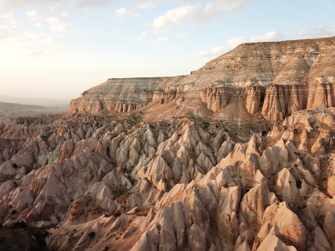
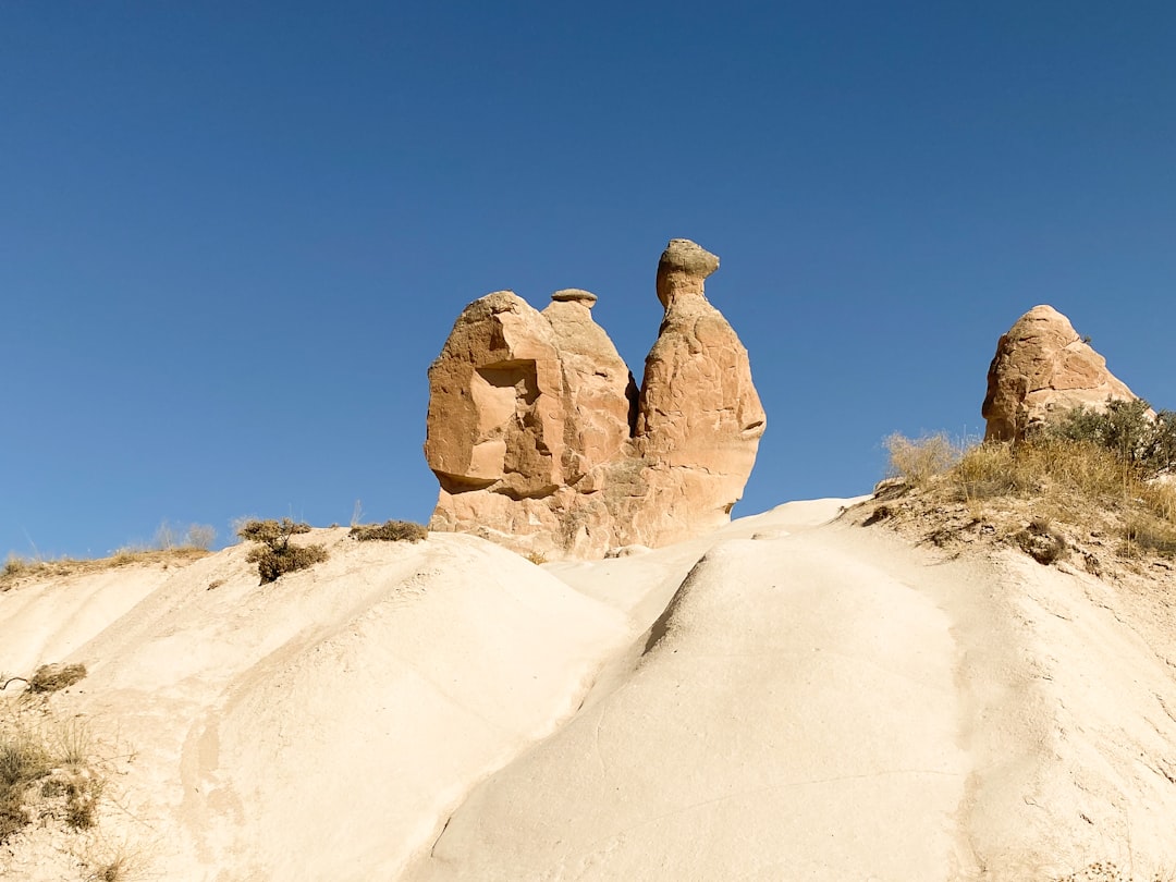
What makes Mushroom Valley distinctive is the concentration of this formation in a relatively small area. The standard fairy chimneys you see elsewhere in Cappadocia — the pointed spires of Göreme, the twin-capped cones of Paşabağ — are variations on the same geological process, but here the caps are unusually wide and flat, and the columns narrow sharply toward the base, amplifying the mushroom resemblance. Walking among them, you get an immediate sense of how actively the landscape is still being shaped: some caps show fresh fracture lines, and collapsed columns leave rubble at the valley floor as reminders that erosion never really stops.
The Valley Landscape
You enter Mushroom Valley from the D400 road between Çavuşin and Avanos, where a small signposted turnoff leads to a dirt parking area. The valley opens gradually — a shallow depression in the plateau, lined with pale tufa cliffs that glow amber and rose in certain lights. The mushroom field itself sits at the heart of the valley floor, a dense cluster of formations that rewards a slow walk rather than a rush-through.
Beyond the main mushroom cluster, the valley holds several other details worth finding. Carved into the cliff walls on the eastern edge are dovecotes — rows of small square holes cut into the rock face by villagers who kept pigeons for their valuable droppings, used as fertiliser on the vineyard terraces that still step up the slopes above. Look up and you will see the terraces clearly, remnants of agricultural life that shaped this landscape long before it became a destination for travellers.
The hiking paths through the valley are informal but clear — beaten dirt tracks that wind between the formations and along the cliff base. The valley floor is relatively flat in its central section, making it easy to navigate without technical gear.
Hiking Through Mushroom Valley
The valley suits walkers of almost any ability, with route options ranging from a brief loop to a longer connection across the landscape.
- Short loop (30 minutes): From the parking area, follow the main path down into the valley floor, circle the mushroom cluster, check the dovecote cliffs, and return the way you came. Enough to see the highlight formations and take photographs without committing to a longer day.
- Çavuşin connection (~2 hours): A trail leads from Mushroom Valley northeast toward Çavuşin village, passing through open tufa terrain with views across the plateau. The route is mostly dirt path with some rocky sections near the village end. Shade is minimal throughout, so carry water and start early in summer.
- Red Valley link: Experienced hikers can connect south toward Red Valley via cross-country paths, though this route requires navigation confidence and is better done with a local guide or detailed map.
Terrain throughout is mostly compacted dirt and loose tufa gravel. Sturdy walking shoes are recommended — sandals work on the short loop but become uncomfortable on the longer routes. The valley has no facilities: no toilets, no cafes, no shade structures. Bring everything you need before you enter.
Photography Guide
Mushroom Valley rewards photographers who think about light and angle rather than just pointing a camera at the formations.
Mid-morning — roughly 8am to 10am — delivers the best side light on the mushroom caps. The low angle catches the texture of the basalt surfaces and throws the narrow column shafts into partial shadow, emphasising the three-dimensional contrast between cap and stem. Avoid midday, when flat overhead light flattens the forms and the pale tufa can wash out.
For balloon shots, Mushroom Valley sits directly beneath a common flight corridor. Sunrise launches send dozens of balloons across this section of the plateau, and if you position yourself on the slight rise at the western edge of the valley — about five minutes' walk uphill from the main path — you can frame balloons against both the mushroom formations below and the wider valley behind. This elevation also gives you a cleaner horizon line than the valley floor.
Sunset turns the tufa columns from pale cream to deep orange and pink, and the soft shadows at dusk restore the textural detail that midday light removes. The eastern cliff faces catch the last warm light well after the valley floor is in shade — useful if you want silhouette shots with a lit backdrop.
What Else Is Nearby
Mushroom Valley sits at the centre of a loose cluster of Cappadocia's most rewarding sites, making it easy to combine with other destinations in a half-day circuit.
- Çavuşin village (10 min walk): One of the oldest continuously inhabited settlements in the region, with a ruined Byzantine cliff village above the modern town and the Church of St. John the Baptist carved into the rock face — notable for its early frescoes and commanding views across the valley.
- Avanos (5 min drive): The pottery capital of Cappadocia, where workshops along the Kızılırmak River have produced terracotta and ceramics from the same red clay for centuries. A visit pairs naturally with the valley — the contrast between natural rock formation and human craft makes each more interesting.
- Red Valley: Accessible via connecting trail to the south, Red Valley takes its name from the iron-rich tufa that glows deep crimson at sunset. One of the region's most dramatic colour experiences.
- Pigeon Valley: Connecting northwest toward Göreme, Pigeon Valley is named for the thousands of dovecotes carved into its cliff walls — the same tradition you see in miniature at Mushroom Valley, but at an overwhelming scale.
Getting There and Practical Information
Mushroom Valley is located directly on the D400 highway between Çavuşin and Avanos, clearly signposted from both directions. Parking is free and available at the valley entrance.
- Entry fee: Free. No ticket required.
- By taxi from Göreme: Around 15 minutes. Get to Mushroom Valley from Göreme by taxi in about 15 minutes — use the Cappadocia taxi price calculator for current fares before you travel.
- By bicycle: The route from Göreme follows relatively flat terrain for most of the way, making it a manageable ride of about 30–40 minutes for a reasonably fit cyclist.
- By car: From Göreme, take the road north toward Çavuşin; the valley turnoff appears on the right before you reach Avanos.
- Opening hours: The valley has no gate or operating hours — accessible any time of day.
- Best season: Spring (April–May) and autumn (September–October) offer ideal conditions: mild temperatures, clear skies, and lower visitor numbers than the summer peak.
Frequently Asked Questions
How long does the Mushroom Valley hike take?
The short loop around the main mushroom formations takes around 30 minutes at a relaxed pace. If you extend the walk to Çavuşin village via the connecting trail, allow approximately 2 hours. Combining the valley with Çavuşin's Church of St. John the Baptist and a return to the parking area makes for a comfortable 2.5-hour half-day outing.
Is Mushroom Valley free to enter?
Yes, completely free. There is no ticket booth, no gate, and no admission charge for the valley itself. This distinguishes it from neighbouring sites like Zelve Open-Air Museum, which does require a ticket. The free parking area at the valley entrance is also at no cost.
What is the best time of year to visit Mushroom Valley?
Spring (April and May) and autumn (September and October) are ideal: temperatures are comfortable for walking, the light is beautiful, and crowds are thinner than in the summer high season. Summer visits are possible but hot — start early, carry plenty of water, and avoid the middle of the day. Winter visits offer solitude and occasionally snow-capped mushroom formations, but check conditions before hiking the longer trail routes.